About CCRA
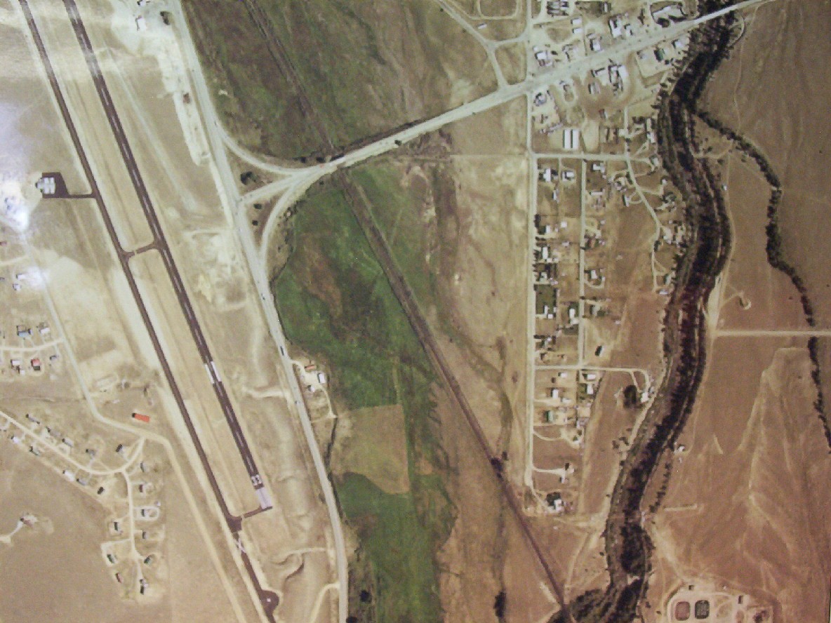
Location
Central Colorado Regional Airport (CCRA) is located only one mile from the center of the Town of Buena Vista. If you are looking for fast access to world-class mountaineering, whitewater adventure, cycling, skiing/snowboarding, snowmobiling, or fishing… look no further. CCRA is classified as a General Aviation Airport and does not have scheduled service.
CCRA has easy access, with an AWOS and GPS approach to our 8,300′ runway. Amenities include a hard pad for heavy aircraft, self-serve/full-serve Avgas and Jet A fuel, a lounge with Wi-Fi, an executive pilot lounge/snooze room, pilot shower facilities, a conference center, a flight planning room, and much more.
Your content goes here. Edit or remove this text inline or in the module Content settings. You can also style every aspect of this content in the module Design settings and even apply custom CSS to this text in the module Advanced settings.
Central Colorado Regional Airport – Announcement of DBE Goals for Federal Fiscal Years 2024-26
Central Colorado Regional Airport hereby announces its proposed Disadvantaged Business Enterprise (DBE) participation goal of 0.3% for FAA-funded contracts/agreements. The proposed goal pertains to federal fiscal years 2024-26 (10/1/2023 – 9/30/2026).
A teleconference (via Microsoft Teams) will be held on January 24, 2024 at 10:00 am for the purpose of consulting with stakeholders to obtain information relevant to the goal-setting process. Please contact the Airport for a meeting invite. Those wishing to participate can phone into the meeting by dialing (480) 378-0989 and when prompted use Conference ID: 482 601 681#.
The FY 2024-26 Overall DBE Goal Methodology document for the Central Colorado Regional Airport is linked HERE.
Comments on the DBE goal will be accepted for 30 days from the date of this publication and can be sent to the following:
Jack Wyles, Airport Manager
27960 County Rd. 319, P.O. Box 2002
Buena Vista, CO 81211
719-395-3496
ccramgr@buenavistaco.gov
Airfield Information & Flight Pattern
Runway 15/33 Elevation 7946 ft
8,300' x 75' Asphalt
Full-length taxiway
Medium Intensity Runway Lighting
(5 clicks on 122.8)
MIRL, VGSI
Runway 15, GPS Departure/traffic right-hand pattern
Runway 33, GPS Approach/traffic left-hand pattern
UNICOM
Freq. 122.800
AWOS Automated Weather Observation Station
Freq. 132.925 | Phone (719) 395-2599

DOCUMENTS
The two DRAFT documents directly below are being made available for Public Review and Comment ahead of work sessions with the Town Board of Trustees. Please send all questions and feedback to the Airport Advisory Board at buenavistacoairportboard@gmail.com. All messages will receive direct replies from the Airport Advisory Board. Thank you for your interest in the future of your airport and our community.
DRAFTS FOR PUBLIC RELEASE:
- KAEJ | Rules and Regulations (2025 DRAFT – FOR PUBLIC RELEASE)
- KAEJ | Minimum Standards (2025 DRAFT – FOR PUBLIC RELEASE)
- KAEJ | Airport Master Plan
- KAEJ | Airport Layout Plan (rev. 2024)
- KAEJ | Business Plan
- KAEJ | Minimum Standards
- KAEJ | Rules and Regulations
- KAEJ | Airpark & Local Aviation Businesses Directory
- KAEJ | Airport Organizational Chart (rev. Apr 2025)
- KAEJ | Airport Fees (rev. Jun 2024)
- KAEJ | 2021 Year End Report
- FAA: Policy on the Non-Aeronautical Use of Airport Hangars
- FAA: Guide to Low-Flying Aircraft | How to Report Low-Flying Aircraft via Flight Standards District Office
LINKS
- NWS: National Weather Service | Buena Vista, CO Forecast
- FAA: AWOS, AEJ Weather Station | Freq. 132.925, (719) 395-2599
- FAA: Mountain AWOS Cameras | Central Rockies
- CDoT: Current METAR Data for AEJ | Aviation Weather Center
- Town of Buena Vista, CO | Official Website
- Town of Buena Vista, CO | ClearGov Transparency Center
- Town of Buena Vista, CO | Job Opportunities